After shrinking to one of the smallest summer extents of the past 30 years, the ice cap over the Arctic Ocean has been re-growing quickly as the dark polar winter tightens its grip.
During November, plunging temperatures refroze an average of more than 30,000 square miles of ocean every day — growing enough pans and floes to cover an area almost the size of South Carolina every 24 hours.
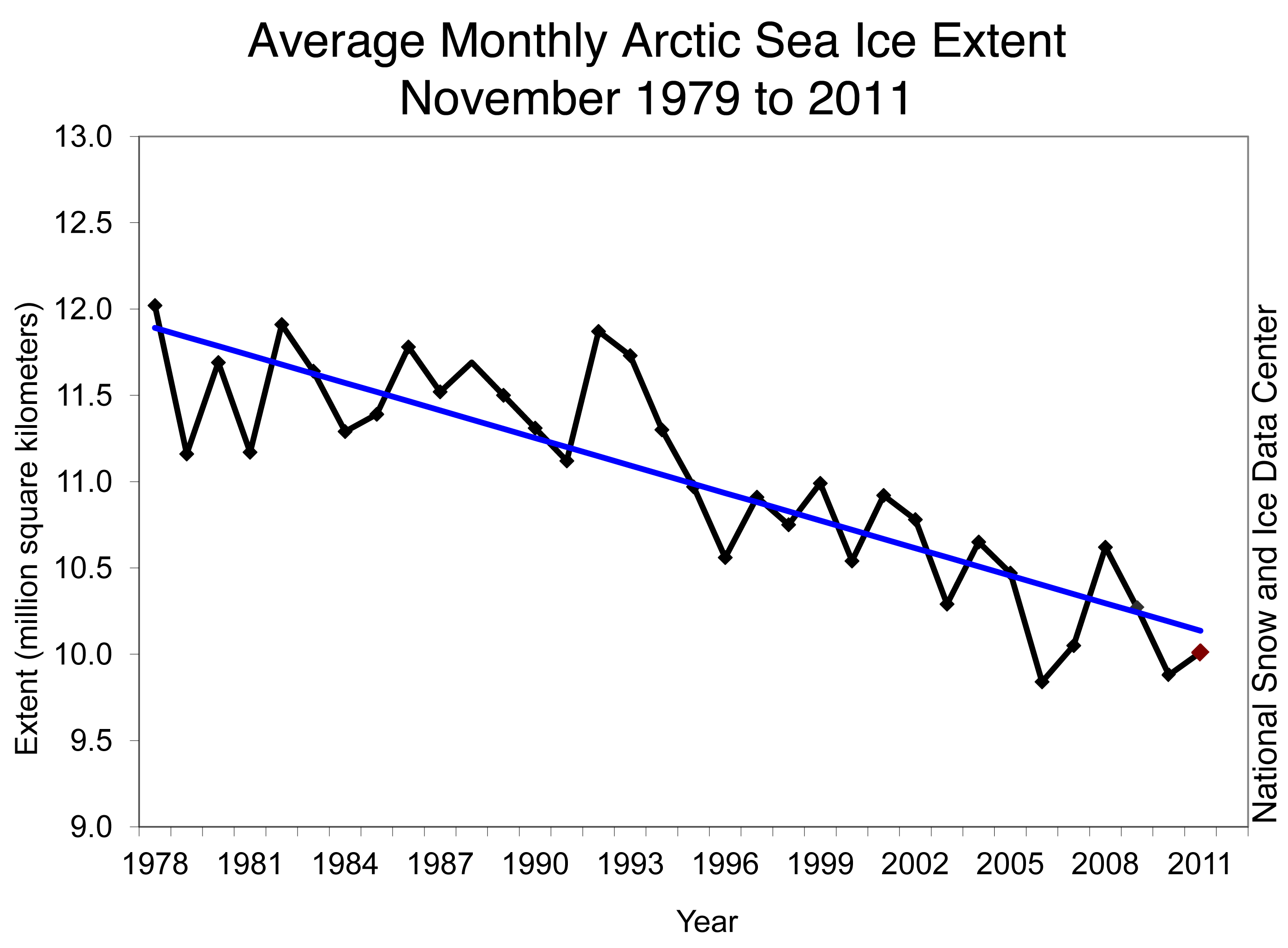
That's faster growth than usual, according to records going back to the 1970s.
And yet, despite weather patterns that plunged the ocean off Alaska's north coast into frigid conditions, the Arctic ice cap remained trapped close to record lows for the time of year, according to the latest sea ice analysis posted by the National Snow and Ice Data Center. Only 2006 and 2010 had a smaller area of sea ice this time of year, the NSIDC said here.
By Nov. 30, the ice cap covered some 4.19 million square miles — about 241,000 square miles above the minimum record for that date set in 2006, but hundreds of thousands of square miles below the long-term average. Overall, November sea ice has been declining about 4.7 percent per year, compared to the 1979-to-2000 average, the NSIDC explained. That's a loss of about 20,500 square miles of frozen habitat each year.
"At the end of November, ice extent remained below the 1979 to 2000 average in the Chukchi, Barents and Kara seas, and Hudson Bay was still nearly ice free," the NSIDC explained. "Ice extent was near average in the East Greenland and the Bering seas. These ice conditions may be connected to a strong positive phase of the Arctic Oscillation, which began during the last week of November."
The long goodbye to ice
Overall sea ice has been declining for a generation, with September of 2011 setting a new record for the smallest seasonal extent ever documented during the 30-year age of satellites.
Observational data from various sources extends the trend further back in time. But a new study released only last month found the declines of recent decades to be unprecedented since about Year 561.
"Although extensive uncertainties remain, especially before the 16th century — both the duration and magnitude of the current decline in sea ice seem to be unprecedented for the past 1,450 years," wrote Christophe Kinnard, a geographer with the Center for Advanced Studies in Chile along with five co-authors from Canada, Norway and Ohio, in a research letter to Nature.
The existence of an ice cap atop the Arctic Ocean plays a critical role in stabilizing the world's climate, and its loss during summer contributes to climate change because darker open water absorbs more solar energy than reflective white floes. The exposed ocean then stores heat that in turn and causes even swifter melt and later fall ice formation.
Summer sea ice also provides habitat used by polar bears, walruses and seals. Without ice for hunting and denning, marine mammals find it much harder to find enough to eat or avoid predators. The United States has listed the polar bear as threatened under the Endangered Species Act due to the shrinking ice pack north of Alaska.
Of storms and chills
One factor that paradoxically helped ice return north of Alaska was a bit of unusual weather.
A massive storm swept in from the North Pacific across the Bering Sea last month, when it slammed Alaska's Northwest Coast with hurricane-force winds and some flooding. As the intense low pressure system drifted north, the counter-clockwise circulation may have contributed to the lower-than-average temperatures now seen in the Chukchi and Beaufort seas, according to the NSIDC analysis.
The NSIDC called it the strongest November storm to hit northwest Alaska since 1974.
Winds that rose past 80 mph in some locations would have made the storm equivalent to a Category 1 hurricane, with a storm surge comparable to a Category 3 storm, a National Weather Service forecaster told NSIDC's Katherine Leitze in a story titled "An Arctic Hurricane?"
"The storm was unusual because it occurred so early in the winter, before sea ice had formed into a thick covering that can dampen waves," Leitze wrote. "Some media coverage of the storm suggested that less sea ice covering the ocean left the coastal areas more vulnerable to the storm than they would have been otherwise. But in the region where the storm hit … sea ice extent was actually pretty close to average for that time of year."
Contact Doug O'Harra at doug(at)alaskadispatch.com